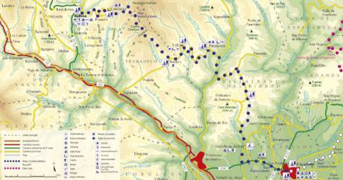
Route 1: Barruelo de Santullán - Balboa - Alto La Varga
Cervera de Pisuerga - Triollo
 High resolution image. This link will open using lightbox, there may be a context switch
 High resolution image. This link will open using lightbox, there may be a context switch From Alto La Varga to Triollo
- TYPE OF COURSE: linear.
- LENGTH: 4.7 km.
- DURATION: 10 minutes.
- SLOPE: 140 m.
- TYPE OF ROAD: road (100%).
- DIFFICULTY OF THE SECTION: low.
- RECOMMENDED TIME: spring to autumn.
In Alto La Varga, you take the so-called Carretera de los Pantanos that leads, in a relaxed descent, to La Lastra. Continuing along the road, the descent concludes in Triollo after crossing the bridge over the Carrión River.
 High resolution image. This link will open using lightbox, there may be a context switch From Alto La Varga to Cervera
- TYPE OF COURSE: linear.
- LENGTH: 19.6 km.
- DURATION: 2 hours.
- SLOPE: 450 m.
- TYPE OF ROAD: forest track (45%) and road (55%).
- DIFFICULTY OF THE SECTION: medium-high.
- RECOMMENDED TIME: from spring to autumn; In winter the route between Rebanal de las Llantas and Alto de la Varga may be closed due to snow.


